Wander along hidden leafy lanes to pass by riverbanks full of wild flowers and wildlife. Picnic beside an ancient mill pond or snack in a beautiful Anglo-Saxon village.
Find out who Battcock's Island was named after. View one of the few artefacts remaining of the St Ives to Huntingdon railway line. Look for eels and trout in Houghton Trout Stream.

This three mile (6,600 steps) walk takes you to hidden leafy lanes, riverside and village. Plenty of spots to picnic or buy lunch or a snack. In winter can be muddy between points 3 and 4. The route is shown below on the Ordnance Survey map. You can also zoom in on a satellite view of the walk at Google Maps.
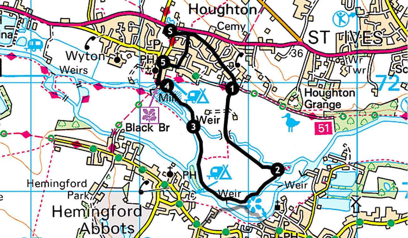
Starting point
Park in the recreation ground car park located to the right on St Ives road, just as you turn off the main A1123 Houghton Hill Road for Houghton. Walk out of the car park, cross the road and head down leafy Meadow Lane, a footpath to the left of the bus stop. This is one of several ancient hidden routes through the village, full of wild flowers and wildlife, with a sleepy stream winding its way below a footbridge on the left.
Continue straight along Meadow Lane. After 300 yards cross a residential road, and another after a further 80 yards. Another 300 yards brings you the Thicket path.

Point 1
Cross straight over to continue walking down Meadow Lane, passing through a metal gate. The fields hereabouts often have alpacas grazing. Follow the lane, the route rising up and over what used to be the railway track from St Ives to Huntingdon.
Just beyond is a bridge over Houghton Trout Stream. A few yards further and after crossing a stile head left, keeping the stream on your left. Follow the track along the field edge as it winds to follow the stream, as shown in the image above.
Point 2
After just over a third of a mile Houghton Trout Stream meets a tributary of the River Great Ouse. Turn right, keeping the tributary on your left. A further third of a mile and you pass into another field. Continue walking along the field edge with the tributary on your left.
Point 3
After 250 yards you'll notice an island in the river tributary. This is Battcock's Island. Cambridgeshire Walks often ponders who landscape features are named after and why. In this case there's an interesting bit of history involved from when Frank Battcock, a forward looking farmer, moved to Hemingford Abbots in 1854 and farmed in the area, including the island.

Continue following the tributary for a further 400 yards. You'll pass along the edges of another two fields. Looking back, catch the beautiful view of St James' Church at Hemingford Grey, as shown in the image above.
You'll reach another footbridge, this one over a weir at the beginning of Houghton Trout Stream. Just below the weir there may be an eel in the shallows.
Beyond the footbridge you pass into a wooded area. Here there are two attractions. The first you'll notice are huge wooden trestles as shown below, all that remains of supports that once carried the St Ives to Huntingdon railway over the River Great Ouse.

The second is a babbling brook caused by another smaller weir, a rare sound in the flat lands of Cambridgeshire. As you cross over a second footbridge look back to the weir and you'll see shoals of fish dancing ahead of the weir in oxygen-rich water.
Cross another footbridge and follow along field edges with the Old Mill Stream on your left. Pass through a turnstile and on the left is a wildlife adventure area, a fun place for kids. As you reach Houghton Mill caravan park on your right, to the left you'll find a picnic spot overlooking the mill pond. This spot is very popular, with safe bathing so long as the mill wheel isn't operating.
Point 4
A couple of hundred yards and you reach Houghton Mill cafe, with its idyllic location of picnic tables overlooking the mill pond. The cream tea is delicious, the savoury version not far behind.
Walk on past the cafe to Houghton Mill. This National Trust property, shown below, is worth a visit if open. A mill has been on this site for over 1,000 years. The current building is from the 1600s. Continue the walk by passing the mill and turning right up Mill Street. Glebe Cottage on the left is a beautiful early 1600s timber framed and thatched cottage. St Mary's church dates from the 1300s.

Point 5
At the top of Mill Street you'll reach the village square. Why not have a wander around Houghton village? It's of Anglo Saxon origin, with evidence of settlement as early as Neolithic times. There are many fine listed buildings in the village. The magnificent, but less than perpendicular, timber framed cottage overlooking the square is the village's oldest house, dating from the 15th century. It was originally a yeoman farmer's house, subsequently the George and Dragon public house. The Clock Tower in the centre of the village square is another favourite stopping point to watch peaceful village life pass by.
Turn right by the memorial to Potto Brown and walk down the Thicket road. About 170 yards on the right is Houghton Manor, a very stylish building where the attention to detail is amazing. A few more yards on the left is Rose Cottage, a tiny 1600s thatched cottage. Turn left up the footpath to the side of Rose Cottage to follow yet another hidden and delightful route through the village.
Head roughly straight on for 300 yards, crossing Home Farm Road, until you find yourself back Meadow Lane. Turn left to return to the car park and the start of the walk.
Click the Print Friendly button below to print out this walk to take with you. Or for more walks click the Return Home button at the foot of this page. Did you enjoy the walk? Notice anything unusual? Why not add a comment below to tell fellow amblers what you liked about it?

No comments:
Post a Comment